Rash of new fires from Monday lightning keeps local crews busy between freeway, Highway 86
Published 8:43 am Tuesday, July 23, 2024
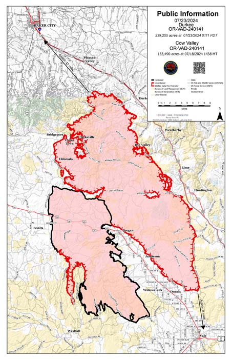
- Map showing the Durkee and Cow Valley Fires as of early July 23, 2024.
Oregon’s biggest wildfire, and the nation’s highest priority fire, is burning on the south side of Interstate 84, but a potent storm with abundant lightning that ignited at least a dozen new blazes north of the freeway on Monday afternoon, July 22, has partially shifted the firefighting focus to that area.
Trending
The new fires have burned several thousand acres, and at least one blaze is threatening homes and prompting evacuation notices.
The Durkee Fire, started by lightning on July 17 south of Interstate 84, has burned 239,000 acres in Baker and Malheur counties, making it the largest fire in Oregon this year.
The fire, which was 0% contained Tuesday morning, July 23, was slightly less active on Monday, growing by an estimated 16,000 acres after growing by about 49,000 acres the previous day, said Jessica Reed, public information officer for the management team overseeing firefighting efforts.
Trending
Most of the growth Monday was on the east flank of the fire, roughly paralleling Interstate 84, Reed said. Firefighters are focusing on protecting structures in the Durbin Creek area west of Huntington.
For this week, weather permitting, fire crews will focus on creating a firebreak starting at the freeway and extending west to the main fire, Reed said. Crews will use burnouts — intentionally igniting fires to consume grass and sagebrush — to accomplish that goal.
Those planned burnouts prompted ODOT to announce that the freeway will be closed daily from 7 p.m. to 5 a.m. between Pendleton and Ontario for the next three to five days.
On the western side of the fire, crews finished burnouts west of Bridgeport and worked to protect structures there.
Reed said the fire has been spreading today east to Interstate 84, although as of 1:30 p.m. it had not crossed the freeway.
The storms that spawned lightning also dropped rain in places.
Reed said rain helped firefighters in only one part of the Durkee Fire — the northwest corner in the Deer Creek area north of the Burnt River.
There was enough rain there to temporarily dampen vegetation turned to tinder during the record-breaking heat wave that started July 5, Reed said.
Crews have been able to hold the fire behind control lines in that area, Reed said.
New fires
The biggest blaze sparked by Monday’s lightning storm started as four separate fires that burned together about 5 miles north of Durkee, said Larisa Bogardus, public information officer for the BLM’s Vale District.
The Thompson Fire was estimated at 8,000 acres late on Tuesday morning.
The fire is threatening homes and prompted the Baker County Sheriff’s Office to issue a Level 3 evacuation notice — meaning leave now — for residents along Vandecar, Manning Creek and Plano roads.
Bogardus said fire crews were dispatched to protect structures, and she had no reports of any homes being burned as of Tuesday morning.
The Coyote Creek Fire, estimated at 3,000 acres, is burning on BLM ground in a roughly triangle-shaped area bounded on the north by the Powder River Arm of Brownlee Reservoir, on the east by the reservoir, and on the west by the Snake River Road. The fire is about 5 miles southeast of Richland, with the Powder River Arm between the fire and the town.
Bogardus said fire crews have solid boundaries, with the reservoir and Powder River Arm, on which to anchor control lines.
Five separate fires burning in Timber Canyon, about 5 miles southwest of Richland, are estimated at a combined 50 to 100 acres.
The Powder Fire, just south of the Powder River about 5 miles southwest of Richland, was estimated at 50 acres on Tuesday morning. Bogardus said there were no visible flames on that fire, but crews are at the site.
At least three other fires were reported between Little Lookout and Big Lookout mountains. No size estimates or other details were available for those fires.
Crews have stopped two other fires — the 8.9-acre Daly Fire near the head of Daly Creek about 10 miles south of Richland, and the 1.1-acre Chalk Fire about 5 miles south of Richland.
In response to the several fires burning between Interstate 84 and Highway 86, the Baker County Sheriff’s Office on Tuesday morning issued a Level 3 evacuation notice — leave now — for a swath of eastern Baker County, east of Iron Mountain Road and Timber Canyon to Brownlee Reservoir, and south of the Powder River to Huntington, including numerous homes and buildings along Brownlee Reservoir. There is no evacuation notice for the city of Richland.
Bogardus said it has been difficult to get an accurate size estimate for the fires because dense smoke has prevented aircraft from flying in the area. She didn’t know as of early Tuesday afternoon whether the Coyote Creek Fire had crossed the Snake River Road to the west or south, and how far east the Thompson Fire has burned.
Resources assigned to various fires in the area include 14 engines, 10 crews (of 20 firefighters each), six bulldozers and eight smokejumpers who parachuted to the Coyote Creek Fire.
On the Wallowa-Whitman National Forest, firefighters on Monday contained a fire near Simmons Creek, about 18 miles south of Joseph, at 0.1 of an acre. On Tuesday firefighters contained a fire in the Happy Canyon area, about 18 miles northeast of Baker City, also at 0.1 of an acre, and a fire near Clear Creek, north of Halfway, at 0.25 of an acre.
More extreme weather possible
Although the National Weather Service is forecasting relatively gentle winds Tuesday out of the north and northwest, a cold front scheduled to sweep through on the afternoon and evening of Wednesday, July 24, could bring much stronger winds, potentially up to 70 mph, as well as more lightning.
The storms are more likely, however, to also deliver rain than the storms earlier this week.
The cold front should end the heat wave, with a high temperature of 86 forecast at the Baker City Airport on Thursday, July 25. That would be the first day below 94 degrees at the airport since July 4.
Marketplace


-
eEdition

-

-
