Project Planned To Protect City Water
Published 8:15 am Saturday, October 31, 2020
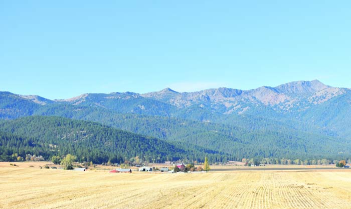
- Baker City’s watershed covers 10,000 acres on the east slopes of the Elkhorn Mountains west of Baker City, ranging from near Elkhorn Peak, the highest point at far right in the photo, south (left) for several miles.
The Wallowa-Whitman National Forest is planning its largest project in about 20 years to reduce the risk of a wildfire spreading through Baker City’s watershed.
Trending
The campaign, which likely won’t start until 2022, involves several tactics, some to be employed inside the 10,000-acre forested watershed, but with a focus on its fringes, said Kendall Cikanek, ranger for the Whitman District.
“What we’re trying to do is create defensible zones between likely sources of ignition and the watershed itself,” Cikanek said.
Almost all of the watershed is public land, managed by the Forest Service.
Trending
The city taps a dozen streams and springs in the watershed to supply almost all of its drinking water. The city also has one supplementary well — which is also used as an underground reservoir to store excess water from the watershed — and a company is drilling a second well now near Quail Ridge Golf Course.
The focus of the Baker City Watershed Fuels Management Project is on the east and south sides of the watershed, including the Washington Gulch and Elk Creek areas.
In those areas a swath of national forest land lies between private property and the watershed.
The Forest Service’s goal, Cikanek said, is to thin overcrowded forests and light prescribed fires in that buffer zone, reducing the amount of combustible material and, ideally, creating zones where firefighters would have a better chance to stop a fire before it burned into the watershed.
The project calls for some type of work, whether cutting trees or prescribed burning, on about 22,600 acres.
Inside the watershed, the priority would be on the major ridgetops, such as those separating Salmon and Marble Creeks, and Mill and Little Mill creeks, Cikanek said.
In those areas workers would cut and pile smaller trees, and later burn the piles, again with the goal of creating “defensible spaces” where the fuel load is reduced and where fire crews would try to block the advance of flames, Cikanek said.
The work would be similar to what has happened over the past two years along the Anthony Lakes Highway near the ski area, Cikanek said.
Because there are few roads in the watershed, it will be expensive to create defensible spaces on the ridgecrests, as workers will have to hike in, he said.
Also, the work will all be “precommercial thinning” — the trees cut will be too small to have any commercial value.
“It’s quite a bit more expensive because of the access,” Cikanek said.
The project does propose commercial logging on more than 5,000 acres, mostly outside the watershed.
The exception is a narrow area along the Marble Creek Pass Road, near the center of the watershed. That’s the only road through the watershed that’s open to the public.
The road, built in the early 1960s as a route to haul limestone from a quarry on the Sumpter side of Elkhorn Ridge to a processing plant near Wingville, is steep and rocky and is not in good enough shape to accommodate log trucks now, Cikanek said.
The Wallowa-Whitman is seeking $1.3 million from federal coffers to rebuild a 6-mile section of the road, a complementary project to the fuels management work.
Cikanek said he’s optimistic that the forest will receive money both for the road improvements and for the fire-reduction work.
Protecting the watershed from fire has been a topic of discussion among city and Forest Service officials for more than a quarter century.
City officials fear that a large blaze in the watershed could foul the springs and streams with mud and ash. That could force the city to find an alternative source of water. It could also force the city to build a filtration plant at a cost likely to exceed $10 million.
The city doesn’t filter its drinking water, being one of a few Oregon cities that use surface water sources that meet federal drinking water standards without filtration.
The city does add chlorine to disinfect the water, and also subjects the water to ultraviolet light to inactivate cryptosporidium. The city installed the UV light system in 2014, the year after cryptosporidium contaminated the city’s water, making many people ill. State officials concluded that feces from cattle illegally grazing in the watershed was the most likely source of the microscopic contaminant.
City Councilor Arvid Andersen, who’s a forestry consultant, has urged the city to make protecting the watershed from fire a top priority.
Andersen said the proposed watershed project is “very positive.”
Michelle Owen, the city’s public works director, said she’s “excited to see some actual movement” on the effort to protect the watershed.
“There’s been a lot of consensus about the need,” Owen said.
Cikanek said some of the areas outside the watershed where tree-thinning and prescribed burning are planned are places where similar work was done about 20 years ago.
These include the upper parts of Elk Creek and along the road under which the city’s water supply pipe runs. That road forms much of the eastern boundary of the watershed.
The Forest Service spent more than $2.2 million over several years during the late 1990s and early 2000s to create defensible spaces along that road and in the Elk Creek area.
Fire overdue in watershed
A study in the mid-1990s by researchers from the University of Washington found that there hasn’t been a large blaze in the watershed in more than a century, in part because the Forest Service quickly responds to the blazes, most of them sparked by lightning.
Emily Heyerdahl and James Agee studied the fire history of the watershed by looking at fire scars on trees and taking core samples of trees.
In their 1996 report, the researchers wrote that in the drier forests of the watershed, including south-facing slopes more exposed to sunlight, fires burned about every 11 years dating back to about 1646.
The cooler, wetter north-facing slopes in the watershed burned less frequently, but Heyerdahl and Agee didn’t have sufficient data to estimate the average interval between those fires.
“What we’re trying to do is create defensible zones between likely sources of ignition and the watershed itself.”
— Kendall Cikanek, Whitman District ranger, Wallowa-Whitman National Forest
Marketplace


-
eEdition

-

-
