Report left out of document could delay Baker City watershed project
Published 9:44 am Friday, January 24, 2025
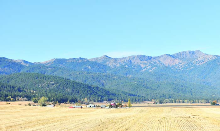
- Baker City’s watershed covers 10,000 acres on the east slopes of the Elkhorn Mountains west of Baker City, ranging from near Elkhorn Peak, the highest point at far right in the photo, south (left) for several miles.
A summary report omitted from the environmental study for a project designed to reduce the risk of wildfire in Baker City’s watershed likely will cause a delay, although a Forest Service official said he hopes work will start on the ground as planned this spring and summer.
Shaun McKinney, supervisor of the Wallowa-Whitman National Forest, said on Friday morning, Jan. 24, that a team of Forest Service officials at the regional office in Portland found the problem when reviewing the environmental assessment for the watershed project.
The assessment, which is required by a 1969 federal law, the National Environmental Policy Act, lacks a summary of the effects the proposed work could have on the environment, McKinney said.
Wallowa-Whitman employees who did the assessment compiled that summary, and it is available online as part of the watershed project files, he said.
But the summary was not part of the environmental assessment itself, he said.
“We tried to streamline the environmental assessment, but we slimmed it down too much,” he said.
As a result, McKinney said, if the Wallowa-Whitman went ahead with the project and a person or organization filed a lawsuit challenging the project, the Wallowa-Whitman would not be able to mount a “vigorous defense” in court due to the flaw in the assessment.
McKinney said that although he has not made a final decision, he believes the more prudent option is to delay district ranger Jeremy Aujero’s approval of the watershed project, which McKinney said last fall could happen around Jan. 31, and add the missing summary to the assessment. He said he has already extended the objection period (previously known as the appeal period) by 30 days.
McKinney said updating the assessment, and having Aujero give final approval for the new version, should take less than 30 days because workers don’t need to do any new work.
“We’re not changing anything,” he said.
Rather, they just need to add the missing summary to the assessment.
Once the assessment includes that summary, McKinney said he believes the Wallowa-Whitman would be in a much stronger position to defend the watershed project against legal challenges.
Aujero’s decision will be subject to objections. McKinney would meet with any objectors and try to reach a resolution that prevents any objectors from filing a lawsuit, which could delay work in the watershed for months or years.
McKinney said he hopes to avoid litigation.
“I know the community has waited so long, and we want to see the fuels reduction and the fire danger reduced,” McKinney said. “We want that done.”
The 10,000-acre watershed, on east the east slopes of the Elkhorn Mountains west of town, extends from Goodrich Creek in the north to Elk Creek at the south end. Major drainages within the watershed include Mill, Little Mill, Marble and Salmon creeks.
The overall project covers about 23,000 acres.
The proposal calls for a combination of commercial logging (on about 3,000 acres), noncommercial thinning of trees under 10 inches diameter (about 14,400 acres), and prescribed burning (about 22,500 acres).
Fire concerns
Forest Service and city officials have been concerned for decades about the risk of a major wildfire in the watershed. Such a blaze could foul streams with ash and dirt, leaving the city, at least temporarily, without its predominant source of water.
(The city also has two supplementary wells, as well as Goodrich Reservoir, which it typically taps only during the summer.)
City officials also have said that a major fire likely would force the city to build a water filtration plant, at a cost of many millions of dollars, to continue using the watershed.
Baker City is one of just three Oregon cities that aren’t required to filter their water to meet federal standards. The city does treat its drinking water with chlorine and with ultraviolet light, both of which are disinfectants.
Although lightning has sparked several fires inside the watershed over the past three decades, firefighters have quickly doused all of those blazes.
Kendall Cikanek, formerly the ranger for the Whitman Ranger District, which includes the watershed, said in a past interview that there hasn’t been a large blaze in the watershed since the 1880s. And based on a study of fire scars on old trees in the area done by researchers from the University of Washington in the mid 1990s, such a blaze, based on historical intervals, likely is overdue.
The Wallowa-Whitman unveiled the current watershed plan in July 2022.
In the late 1990s the Wallowa-Whitman spent more than $2.2 million to cut trees and light prescribed fires to create fuelbreaks on the fringes of the watershed. Most of the work was on the south end and along the road under which is buried the city’s water pipeline, with a goal of giving fire crews a place to head off a blaze moving toward the watershed.
The current project would build on those past efforts but also expand the work inside the watershed boundaries.
Commercial logging
Most of the logging that produces trees large enough to be sold to mills would happen outside the watershed.
Areas where commercial logging is proposed include in upper Washington Gulch, California Gulch north of Highway 7, and on public land in the lower sections of Salmon Creek, Rouen Gulch and Hibbard Gulch.
Most commercial logging proposed inside the watershed is concentrated in the Marble Creek area. That’s partly because the Marble Creek Pass Road, the only public road that goes through the watershed, is nearby.
One issue that wasn’t settled in the draft environmental assessment the Wallowa-Whitman released in March 2024 was whether the project would include cutting of live trees more than 21 inches in diameter.
A Forest Service policy from the early 1990s banned cutting of trees of that size, after environmental groups decried the scarcity of old-growth trees in Eastern Oregon forests. But in early 2021 the outgoing Trump administration ended that ban. It was later replaced with a more flexible policy which is the subject of legal challenges.
The draft and final environmental assessments both include two alternatives, one calling for logging trees larger than 21 inches, and one which does not.
Wallowa-Whitman officials chose the latter option, which does not include cutting trees bigger than 21 inches in diameter. According to the final environmental assessment, the amendment to the 1990s policy that allowed logging of larger trees is not valid “due to circumstances associated with recent litigation.”
Noncommercial tree thinning, prescribed burning
These two tactics constitute the bulk of the work proposed both inside and outside the watershed.
The overriding goal is to reduce the amount of fuel in and around the watershed — standing trees and down logs that can feed a wildfire, McKinney said earlier this year.
The idea, McKinney said, is that even if a fire starts outside the watershed, by reducing the amount of fuel the Forest Service would slow the spread of the flames and give fire crews a better chance to either keep the flames out of the watershed altogether, or to confine it to a relatively small section of the watershed. A major part of this strategy involves creating “defensible fuel profile zones” or, most simply, fuelbreaks.
In these areas, workers would use a combination of thinning and prescribed burning to make linear strips, as wide as 600 feet, where the relatively scarcity of fuel would likely slow the spread of a fire. These fuelbreaks would be built in two major places, McKinney said — along roads, which firefighters have always used as anchors for firelines, and along the tops of several ridges.
Fuelbreaks are proposed along the Pipeline Road, which forms much of the eastern boundary of the watershed, as well as sections of other roads outside the watershed.
Ridgetop fuelbreaks are planned between major drainages such as the ridge between Salmon and Elk creeks, and Salmon and Marble creeks.


