TRAILS: Ten trails in the Elkhorn Mountains
Published 12:00 am Thursday, August 10, 2006
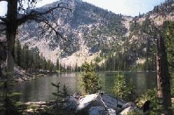
- Summit Lake, near the center of the Elkhorn Mountains, is the second-largest lake in the mountains. Only Rock Creek Lake is bigger. (Baker City Herald/Jayson Jacoby).
By JAYSON JACOBY
The Wallowa Mountains, also known as the Switzerland of America and Oregon’s Alps, are by far the best-known alpine area in Eastern Oregon.
Thousands of people hike the hundreds of miles of trails in the Eagle Cap Wilderness, which encompasses most of the Wallowas.
The Elkhorns, a smaller mountain range 20 miles southwest, are mostly ignored. Yet only the Wallowas have more hiking trails and, unlike those in the federally protected Eagle Caps, many Elkhorn trails are open to mountain bikes as well as to hikers and horseback riders. Motorcycles are even allowed on a few.
The following is a list of trails on the east and south sides of the Elkhorns. West- and north-side trails will be featured next Thursday. More detailed information is available by visiting the Baker Ranger District, 3165 10th St., or by calling the office at 523-4476. Employees there can provide necessary maps and tell you when a trail was last maintained.
Phillips Reservoir shoreline
WHERE: 17 miles SW of Baker City
ACCESS: Drive south on Highway 7. Best access points are on the south side of Mason Dam (the road across the dam, Black Mountain Road, begins on the left side of the highway about 17 miles from Baker City), Union Creek Campground, Social Security Point and Mowich Loop Picnic Area on the reservoir’s north shore, Southwest Shore and Miller’s Lake campgrounds on south. To get to the south shore, turn left on Hudspeth Lane at the reservoir’s west end
DISTANCE, DIFFICULTY: 10 miles around reservoir, mostly flat.
OPEN TO: Hikers, horses, bicycles
HIGHLIGHTS: Views of the reservoir and Elkhorns, fishing, swimming, bald eagle nest platforms near Miller’s Lane Campground
Indian Rock
WHERE: 20 miles SW of Baker City
ACCESS: Highway 7, turn right on Union Creek Road just east of Union Creek Campground, drive 200 yards, look closely for trail on right sight of road
DISTANCE, DIFFICULTY: 1 mile, 400 foot elevation gain
OPEN TO: Hikers, horses, bicycles, motorcycles
HIGHLIGHTS: Bird’s eye views of Phillips Reservoir and Sumpter Valley
Red Mountain Lake
WHERE: 15 miles NW of Baker City
ACCESS: Drive on Anthony Lakes Highway four miles past Haines, continue straight where road turns sharply to right, follow sign for Rock Creek; drive straight 2.6 miles, continue straight where road bends left; one mile farther turn left at sign for Bulger Flat
DISTANCE, DIFFICULTY: 1 mile, 1,200-foot elevation gain
OPEN TO: Hikers, horses, bicycles
HIGHLIGHTS: Rushing mountain stream, fishing for brook trout in beautiful green-watered lake
Summit Lake
WHERE: 17 miles NW of Baker City
ACCESS: Same as for Red Mountain Lake
DISTANCE, DIFFICULTY: 1 mile, 1,100-foot elevation gain; trail continues past lake 1.5 miles to Elkhorn Crest Trail; 200-foot elevation gain
OPEN TO: Hikers, horses, bicycles
HIGHLIGHTS: In early summer, mushrooms in the 1989 Summit Lake burn, fishing, craggy cliffs above lake
North Powder River
WHERE: 20 miles NW of Baker City
ACCESS: Same as for Red Mountain and Summit lakes
DISTANCE, DIFFICULTY: 2.5 miles, 1,400-foot elevation gain to Elkhorn Crest Trail; 3 miles, 1,100 feet to Lost Lake
OPEN TO: Hikers, horses, bicycles, motorcycles
HIGHLIGHTS: Route of 19th century Haines to Bourne stagecoach road, access to good fishing at Lost Lake
Killamacue Lake
WHERE: 15 miles NW of Baker City
ACCESS: Drive on Anthony Lake Highway two miles past Haines, continue straight at first right corner, follow signs to Rock Creek
DISTANCE, DIFFICULTY: 3 miles, 1,550-foot elevation gain
OPEN TO: Hikers, horses, bicycles, motorcycles
HIGHLIGHTS: Tamarack forest, decades-old rock work at lake’s outlet
Rock Creek Lake
WHERE: 17 miles NW of Baker City
ACCESS: Same as for Killamacue Lake, trailhead about three miles farther on Rock Creek Road
DISTANCE, DIFFICULTY: 4 miles, 2,000-foot elevation gain
OPEN TO: Hikers, horses, bicycles
HIGHLIGHTS: Spectacular cliffs on Elkhorn Ridge, deep (100 feet) dark-blue lake
Dutch Flat Lake
WHERE: 25 miles NW of Baker City
ACCESS: Drive on Anthony Lakes Highway 25 miles from Baker City; road to trailhead is marked with sign on left side
DISTANCE, DIFFICULTY: 7.5 miles and 1,800-foot elevation gain to Dutch Flat, 9 miles and 2,300 feet to Dutch Flat Lake, 10 miles and 2,800 feet to Elkhorn Crest Trail
OPEN TO: Hikers, horses, bicycles
HIGHLIGHTS: Scenery varying from dense spruce forest to alpine meadow to granite peaks
Pine Creek Reservoir
WHERE: 10 miles W of Baker City
ACCESS: Drive on Pocahontas Road to Pine Creek Road. Turn left, follow for two miles to andquot;Tandquot; junction, turn right, cross creek and turn left on gravel road
DISTANCE, DIFFICULTY: Road is almost impassable, even to four-wheel drive vehicles. From end of graded gravel, about five miles and 2,100-foot elevation gain; many hikers cross ridge west of reservoir to Rock Creek Lake, as well
OPEN TO: Hikers, horses, bicycles and motorcycles
HIGHLIGHTS: For off-road enthusiasts, a challenging trail; views of Elkhorn Peak, at 8,931 feet the second-highest peak in the range
Elkhorn Crest Trail
WHERE: 12 miles W of Baker City
ACCESS: Trailheads at Anthony Lakes and Marble Pass
DISTANCE, DIFFICULTY: 23 miles, mostly flat, although 1,200-foot elevation gain in three miles from Anthony Lakes to Angell Pass, 700-foot climb in four miles from Marble Pass to Twin Lakes, 700-foot climb in four miles from Cracker Saddle to Lost Lake Saddle
OPEN TO: Hikers, horses, bicycles and motorcycles on 13-mile section from Marble Pass to Cracker Saddle; hikers and horses from Cracker Saddle to Anthony Lakes
HIGHLIGHTS: Best views in Baker County
All of the trails listed are at high elevations where the weather changes dramatically and suddenly.
In addition, trailheads for Killamacue, Rock Creek, Summit and Red Mountain lakes and the North Powder River are accessible only by four-wheel drive vehicles. The road to Marble Pass, at the south end of the Elkhorn Crest Trail, is rocky and steep. Four-wheel drive isn’t required, but it’s not a good road for low-clearance passenger cars, either.