Baker County farmers, ranchers optimistic about water supply as drought diminishes
Published 2:39 pm Wednesday, April 16, 2025

- A center-pivot sprinkler in the Baker Valley with the snowy Elkhorn Mountains in the background on March 31, 2025. (Jayson Jacoby/Baker City Herald)
Curtis Martin was pleased to see pools of water where he had never seen them before.
He just hopes the water doesn’t start moving.
Martin, a cattle rancher who lives near North Powder, is more accustomed to worrying about a shortage of water than a surplus.
The grazing land he owns in the Cow Valley area of northern Malheur County, along Highway 26 between Ironside and Brogan, is far more often desiccated than it is moist.
But a series of snowstorms in early February, followed by a thaw later in the month, spawned the ponds that Martin saw during a visit to his range ground in early March.
The standing water raises the prospect for a lush crop of grass that Martin’s cattle — and the herds that dozens of other ranchers depend on across the region — can munch on this spring and summer.
The reason his optimism is tinged with concern has to do with fire.
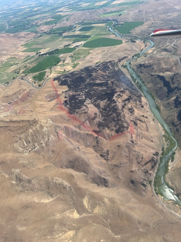
In July 2024 the Cow Valley fire, an arson-caused blaze that remains under investigation, spread across 133,490 acres in northern Malheur County, propelled by gusty winds.
Martin, who grew up in the area, graduated from Vale High School in 1973 and owns about 6,000 acres around Cow Valley, used a bulldozer to carve firelines that saved his family’s 50-year-old cabin from the flames.
Although he appreciates the snow, which should soak into the ground and help scorched grasslands recover, Martin fears that heavy rain this spring, especially if combined with high temperatures that rapidly melt snow at higher elevations, could lead to flash floods that scour soil off steep slopes.
“My biggest concern for my property is warm weather,” Martin said on March 5. “We could lose a lot of soil to erosion.”
He said the places where the fire burned hottest are especially vulnerable.
Those areas, with little or no vegetation on the surface, or roots below ground, have little resistance to moving water.
Martin estimated that 80% to 85% of his grazing land burned, with the severity ranging from light to extreme.
In places the fire killed everything, including the relatively deep roots of the native Idaho fescue and bluebunch wheatgrass that made the area so valuable for livestock grazing.
On the positive side of the ledger, Martin said that if the spring weather is benevolent, with occasional rain but no extended downpours, the recovery of burned land should get something of a jumpstart.
November 2024 was wetter than usual across Northeastern Oregon.
And the rain fell before the ground was frozen, so the water percolated into the soil.
Most of January was dry, but the early February storms piled a prodigious mountain snowpack, a primary source of water, including for irrigation.
Periodic storms continued into early April, keeping the snowpack well above average across most of Northeastern Oregon.
“It’s looking great,” Martin said.
Reprieve from drought
Martin isn’t alone in noticing the unusually saturated situation in Cow Valley and elsewhere.
Mark Bennett, who with his wife, Patti, owns a cattle ranch near Unity, in southern Baker County, frequently drives Highway 26 to Vale, a route that passes through Cow Valley.
What drew Bennett’s eye — and provoked a chuckle or two — is the highway bridge over Cow Creek.
Bennett, a former Baker County commissioner, said in more than 40 years of living nearby he’s rarely seen any water in this stream — and then the flow was a trickle rather than a torrent.
But on March 11, while driving east to Vale to pick up some ranch equipment, Bennett realized, as his truck approached the bridge, that Cow Creek was at least living up to its name.
“I almost pulled over and took a picture,” he said, so surprised he was by the vigorous volume of snowmelt tumbling down the usually arid channel among the sagebrush.
Bennett was amused, as well as shocked, because of a sign that used to be posted at that bridge.
The sign warned against jumping from the structure.
Given the almost constant absence of water below — the typical thing that lures people to leap from bridges — Bennett said he always wondered what had prompted the seemingly superfluous sign.
Bennett said he’s optimistic about the water outlook this year based on the snowpack.
“So far it seems to be pretty good,” he said. “There was heavy runoff this past weekend, and it seems to be soaking in.”
Whether the streams and springs on his ranch continue to flow well into summer depends on how much rain falls this spring.
Regardless, Bennett said the situation is much more promising than it was for several years in the past decade, particularly from around 2019-22, when drought dominated.
The weekly U.S. Drought Monitor reflects Bennett’s optimism.
Since March 19 the map of Oregon has been blank, meaning no part of the state, including the northeast corner, was in a drought — or even rated as abnormally dry, the category that precedes the four levels of drought: moderate, severe, extreme and exceptional.
That hadn’t happened since November 2019.
Watching a reservoir
Mark Ward doesn’t choose Martin’s superlative when asked to describe the moisture situation in his family’s crop fields in early March.
“I think we’re medium, average, right down the middle,” said Ward, whose family grows peppermint, potatoes, wheat, alfalfa and silage corn in Baker Valley
Ward said he was grateful for the snowstorms in early February, and disappointed that the snow, at least at lower elevations, melted within a couple weeks.
“I wasn’t ready to see winter be over with,” Ward said. “I’d like another foot of snow.”
Winter did indeed linger in the mountains.
A couple of Pacific storms that swept inland during mid-March, and another period of wintry weather at the end of the month continuing into the first couple days of April, bolstered a mountain snowpack that in parts of the region hovered near record highs for much of the winter.
The snowpack is especially bountiful in the southern half of the Wallowa Mountains, on the west side of the Elkhorns and in parts of the southern Blue Mountains, including the Strawberry Range.
The water content in the snow — a statistic more relevant, in predicting water supplies, than snow depth — is also above average in much of the northern Blue Mountains, but not as far above as in other areas.
Melting snow, in addition to replenishing ground depleted during the drought that has prevailed for much of the past decade, also trickles into reservoirs.
For Ward, the key impoundment is Phillips Reservoir, along the Powder River about 17 miles southwest of Baker City.
Its waters irrigate more than 30,000 acres, mainly in Baker Valley.
Ward is a board member for the Baker Valley Irrigation District, which manages water releases from the reservoir, which was created when Mason Dam was finished in 1968.
Phillips Reservoir hasn’t filled since 2017.
And Ward doesn’t expect that streak to end in 2025.
He said board members, based on the reservoir’s level in early March — about 33% full — concluded that it’s likely to top out around 75% of capacity.
Phillips is considered full at 73,000 acre-feet, although it can store more water if needed for flood control.
(One acre-foot of water would cover one acre of flat ground to a depth of one foot. The figure is equal to about 358,000 gallons.)
Based on that prediction, Ward said he and other farmers who have rights to water stored in the reservoir likely will get from one acre-foot to 1.5 acre-feet of stored water per acre of irrigated ground.
When the reservoir is full, their allotment can be as much as 3.5 acre-feet per acre.
Phillips began refilling rapidly during March due to a period of warmer weather that started to melt snow at lower elevations in the Powder River basin. As of April 16 the reservoir was 63% full.
Although snowpack has the biggest influence on the reservoir level, other factors can play a role as well, Ward said.
Spring rain is the most important, particularly if it falls before early to mid June.
Rain helps in two ways, Ward said.
The obvious benefit is that rain keeps fledgling crops moist.
But also, generally speaking, the more rain that falls during April, May and the first part of June, the less water the irrigation district has to release from the reservoir.
“If it rains like it can, that’s just great,” Ward said. “But the stars have to line up.”
Although May is on average the wettest month in Baker Valley, and June ranks second, Ward said the gusty winds that often follow spring rainstorms can quickly dry the top layer of soil, forcing farmers to use more irrigation water than they otherwise would.
Another factor is fire.
Two blazes, one in 1989 and the other in 2015, burned thousands of acres on and around Dooley Mountain, about a dozen miles south of Baker City.
The fires killed most of the trees in the previously dense forests of pine and fir, and without their shade, the snow melts earlier in the spring than it used to, Ward said.
Those areas are downstream from Phillips Reservoir, so the melting snow flows into the Powder River and can’t be stored.
Ward said that before the 1989 fire, melting snow from Dooley Mountain in some years fulfilled the demand for irrigation water in much of Baker Valley, allowing the irrigation district to save most of the upstream runoff in the reservoir.
Grateful for last fall’s rain
Although spring rain is especially valuable for farmers, storms that happened several months ago have a lingering benefit, Ward said.
That’s especially true for mint, a shallow-rooted crop.
Ward said autumn rain, if it falls before the ground freezes, can moisten the top 6 inches or so of soil, including the mint plants’ root zone.
Mint thrives in such conditions, he said, and in the year after a damp fall the plants tend to produce more of the pungent oil that is distilled and then sold to companies that use the liquid to flavor products such as toothpaste and chewing gum.
“It’s a huge benefit,” Ward said. “This is the first time in 10 years or so that our mint went to bed, so to speak, adequately hydrated during that crucial period. That benefits the health of the plant going into winter.”
Commodity concerns
Ward said markets for many regional crops, including wheat, alfalfa, barley and silage corn, are not promising.
“The only really bright spot I see is livestock,” he said.
Although his family’s operation is still called Ward Ranches, reflecting its history in the cattle business, they sold their herds in the early 1990s.
AgWest Credit Union issued its spring commodity outlooks on March 12.
Cattle
“Low cattle inventories continue to sustain strong margins for most cow-calf producers,” AgWest reported. “Improved moisture in the Pacific Northwest and Montana has eased the need for herd reductions, while drought in the Southwest and Midwest has sharply cut cattle numbers. Sustained dry conditions in most major cattle producing areas are expected to constrain herd rebuilding which will support cattle prices through 2025.”
Wheat
“Wheat producers face another challenging year in 2025. Prices are projected to remain below breakeven levels, fluctuating between $5.45-$6.00 per bushel in 2025,” AgWest reported. “Growers also face higher costs including rising repair and maintenance costs, along with inland basis and transportation expenses exceeding $1.00 per bushel. This follows on the heels of a difficult 2024, where most growers experienced financial losses and decreased working capital.”
Hay
“Hay producers face a difficult operating environment marked by low prices, higher-than-normal inventory levels and increased operating debt,” AgWest reported. “To move inventory, some growers are selling hay at discounted prices.”