Weather turns from antagonist to ally for crews fighting Durkee Fire; blaze 20% contained
Published 5:42 am Thursday, July 25, 2024
- 452917279_122106508976400567_5079631747062754063_n.jpg
After playing the villain for a week, turning a single lightning bolt into the biggest wildfire in Oregon and the nation, the weather suddenly turned into an ally for firefighters.
Thunderstorms spawned by a cold front that broke the worst heat wave in Baker County’s history doused most of the Durkee Fire with rain on Wednesday evening, July 24.
A single storm can’t end a fire that has burned more than 284,000 acres — about the size of Multnomah County — and cost an estimated $8.7 million to fight.
But the downpour was a welcome change for firefighters who have battled triple-digit temperatures and nearly constant wind since the fire started south of Durkee on the morning of July 17.
Baker County Sheriff Travis Ash, who has been spending most of his time since then working with deputies and search and rescue members to notify residents across a broad swath of the county about frequently changing evacuation levels, on Wednesday evening called the rain a “godsend.”
The storm had one nearly immediate effect, as Ash reduced the evacuation level for Huntington, Baker County’s second-most populous city with about 510 residents, from Level 3 — leave now — to the lowest stage, Level 1 — be set.
The sheriff’s office announced that further reductions in evacuation levels elsewhere were likely on Thursday.
Jessica Reed, public information officer for the Durkee Fire management team, said Thursday morning that rainfall across the fire averaged about one-quarter inch. Humidity levels also increased to the highest in the past week.
“That really helped moderate fire activity,” Reed said.
During a recorded briefing by fire managers that was posted on the Cow Valley and Durkee Fires Information 2024 Facebook page on Wednesday evening, Tyson Albrecht, the incident commander, said “that fire has just not cooperated with us in terms of weather.”
“I don’t like fires outpacing me, so that’s a hard thing to admit,” said Albrecht, who grew up in Baker City. “This fire, and the weather that we’ve been experiencing has been challenging us. We’re working as hard as we can to minimize all those impacts.”
The storm’s effects weren’t wholly beneficial.
Before the rain sluiced down, winds gusted to at least 60 mph, pushing the fire across Interstate 84 near Huntington and across the Burnt River near Deer Creek.
Reed said firefighters stopped the fire from spreading far beyond Interstate 84.
A 30-acre fire across Old Highway 30 was reported about 3:30 p.m., during the windiest period, but firefighters, including an Oregon State Fire Marshal’s Team and a Union Pacific Railroad train that sprayed water, stopped the fire and protected three structures.
Because weather grounded aircraft on Wednesday, including the airplane that uses infrared sensors to estimate the fire’s size, the amount of growth Wednesday wasn’t known this morning, Reed said.
With more tranquil weather today, she said aircraft will be available to help firefighters on the ground as they work to build new lines, strengthen existing ones and tie lines together.
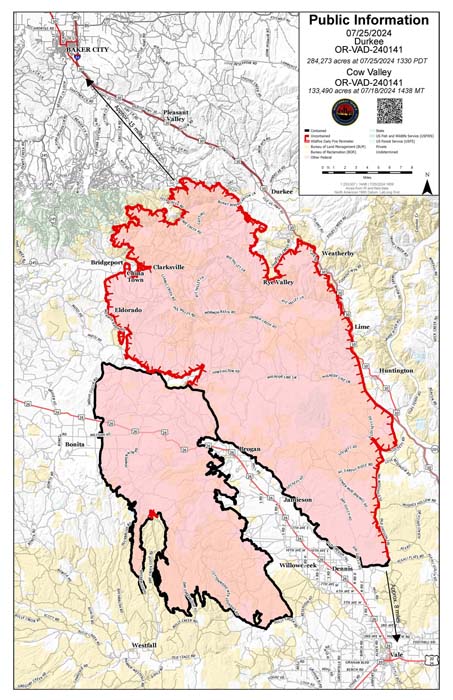
Fire officials announced Thursday afternoon that the Durkee Fire is 20% contained. The section that is considered contained is in the southwest section.
Reed said that reflects the conservative criteria fire managers use to determine containment levels, not actual progress on checking the fire’s spread.
At the southern tip of the fire, for instance, in Malheur County, the fire hasn’t spread for a few days, and Reed said fire managers “are feeling pretty confident that it won’t grow” in that area.
However, she said they need to be “100 percent confident” that fire lines will hold before declaring that section of the fire contained.
“We don’t take saying that lightly,” Reed said.
In an update about 6:15 p.m. on Thursday, Reed, said a weather station along Shirttail Creek, southeast of the Ash Grove Cement plant, recorded northwest winds at 36 mph with gusts to 46 mph.
The most active part of the fire Thursday, though, was north of Bridgeport, an area that Reed said didn’t get any rain from Wednesday’s storm.
The Thompson Fire, started by lightning on July 22 and burning north of Durkee, also grew rapidly during the strong winds, including in the Sisley Creek area northeast of Durkee.
Those flare ups prompted the sheriff’s office to add evacuation notices, including a Level 1 notice that extended northwest of the Durkee Fire nearly to Baker City, and Level 3 for areas north of Durkee.
Firefighters from local volunteer districts, along with state and federal agencies and task forces from the Oregon State Fire Marshal’s Office, have been working to protect homes, and there are no reports of any homes being burned.
A series of storms also produced hundreds of lightning strikes, some of which sparked fires.
The National Weather Service reported about 2,800 lightning bolts in Eastern Oregon and Southern Idaho on Wednesday, the ninth-highest total for a July day since 2000.
Several new fires were reported, the largest, as of Thursday afternoon, a 90-acre fire on the Idaho side of Hells Canyon Reservoir near Oxbow. A 15-acre fire was reported near Skinner Lane near Keating, about 14 miles northeast of Baker City. The fire was contained as of Thursday afternoon.
An incident management team is also taking over planning for the Badland Complex fires, all started by lightning July 22 between Interstate 84 and Highway 86 and totaling about 51,000 acres as of Thursday evening — Thompson Fire, 31,000, Coyote, 19,000, and Powder, 1,000. That team is headquartered at Baker High School.
The Thompson Fire is the biggest of the fires, burning about 5 miles north and northeast of Durkee. Crews focused Wednesday on protecting structures in the Sisley Creek, Daly Creek and Plano Road areas. Firefighters had to seek shelter during the height of Wednesday’s thunderstorm, according to the BLM.
The other major fire that’s part of the Badlands Complex is the Coyote Fire, south of the Powder River Arm on Brownlee Reservoir. The fire, estimated at 6,000 acres, spread north on Wednesday, coming close to structures on the Powder River but not threatening them, according to the BLM. The fire also crossed to the west side of the Snake River Road and burned into Daly Creek.
Alison Oszman, who lives in Rye Valley northwest of Huntington, said the rain helped as a group of firefighters and volunteers, herself included, worked to save a home threatened by fire along Rye Valley Lane about one mile from Interstate 84 at Exit 340.
Welcome precipitation
Rain amounts varied, as is typical with thunderstorms.
A remote weather station set up along Shirttail Creek near Rye Valley, southeast of the Ash Grove Cement plant, recorded 0.29 of an inch of rain. The relative humidity, which can play a major role in how fast fire spreads, peaked at 83%. The maximum humidity on Tuesday was 41%.
A weather station near Morgan Mountain, north of Interstate 84, measured 0.48 of an inch of rain.
A remote station in Dark Canyon near the Burnt River, between Bridgeport and Durkee, did not record any rainfall.
Other rainfall totals:
• Baker City Airport: 0.11 of an inch
• Blue Canyon, near Old Auburn Lane southwest of Baker City: 0.52
• Mason Dam: 0.41
• Upper Elk Creek southwest of Baker City: 0.58
• Unity Dam: 0.41
• Yellowpine Campground, northwest of Unity: 0.47
• West of Richland along Powder River: 0.20
• Oregon Trail Interpretive Center: 0.20
• Sparta Butte, northwest of Richland: 0.01
Storm batters Baker City
Strong winds and heavy rain hit Baker City around 3:30 p.m. on Wednesday.
Gusts toppled several trees and snapped limbs from many others.
The Baker City Public Works Department responded to more than 20 calls about trees or limbs partially or completely blocking streets.
Heat wave ending
The cold front responsible for Wednesday’s storms also shoved aside the persistent and intense high-pressure ridge that led to the most severe heat wave in Baker County history.
From July 5-24, the temperature was 94 or higher every day at the Baker City Airport. The 20-day run of 90-degree-plus days broke the previous record of 16, set in 1994 and tied in 2007.
On 10 of the 20 days during the heat wave the temperature at the airport rose to 100 or higher. That broke the record for triple-digit days not only in one month, but in a full calendar year. The previous record was eight such days, in 1961.
The National Weather Service is forecasting a high of 85 on Thursday.
This July is almost certain to be the hottest month at the airport, where temperature records date to 1943.
Through July 24, the average daily high was 97.1 degrees. The hottest month on record is July 2021, when the average high was 92.3. The long-term average high for July is 85.5.


-
eEdition

-

-