Record rain on July 21 temporarily eased wildfire danger in Blue Mountains
Published 7:00 am Thursday, July 24, 2025


A record-breaking rainstorm on July 21 eased the wildfire danger across Northeastern Oregon, but U.S. Forest Service officials say the effects probably won’t last much longer than a week as more typical summer weather prevails.
Rain fell across the Blue Mountains during the storm, which was unusually potent for July and more resembled an early spring weather pattern.
The storm was especially soggy in parts of the Wallowa-Whitman National Forest, including in Baker County.
Trending
Several remote weather stations recorded rainfall amounts of between half an inch and nearly one inch.
A station near the head of Elk Creek, at the southern edge of the Baker City Watershed, measured 0.7 of an inch.
The Baker City Airport had 0.5 of an inch on July 21, breaking the daily record of 0.26 of an inch. The one-day total matched the average for all of July.
It was the wettest July day at the airport in a decade. On July 10, 2015, an all-time July daily record of 2.03 inches fell.
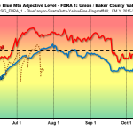
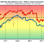
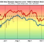
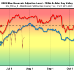
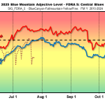
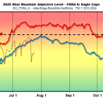
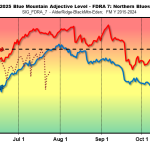
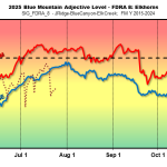
The July 21 storm had a significant effect on one of the indexes that fire managers track to get a sense of the wildfire danger. The index is called the energy release component (ERC), and it basically estimates how fast a fire would spread based on fuel moisture.
The ERC in each of eight zones in the Blue Mountains dropped significantly on July 22, to well below average for the date.
Trending
The ERC has been rising since, although it remained below average as of July 24.
In response to questions from the Baker City Herald about the storm’s effects on fire danger, local Forest Service officials referred the request to the agency’s regional office in Portland.
The regional office of communications and community engagement responded in an email that “we anticipate it may take about 5–7 days for fire conditions to return to previous levels” on the Wallowa-Whitman.
On the neighboring Umatilla National Forest, the rain and cooler temperatures caused “a noticeable decline in fire danger indices, particularly in the energy release component and burning index, which we monitor daily,” according to the regional office.
“While we expect this decrease to be short-lived lasting approximately 5–10 days, it has provided a crucial opportunity for our teams to make progress on local projects. Additionally, it has allowed us to mobilize extra resources in support of incidents throughout the broader geographic area.”
Weather forecast
The National Weather Service is predicting dry, warm weather through the end of July.
The month is on pace to be the coolest July at the Baker City Airport since 2016. Through July 24 the average high temperature was 85.0 degrees, slightly below the long-term average of 85.6. Although the monthly average is likely to increase based on the forecast for highs in the upper 80s and low 90s, the month likely will end up with the lowest average high since 82.4 degrees in 2016.
Last July, by contrast, was the hottest on record at the airport, for any month, with an average high of 94.9 degrees. The temperature topped 90 degrees on 22 of the 31 days in July 2024.
This July, through the 24rd, there were nine 90-degree-plus days.
The summer of 2024 set a record at the airport with 54 days when the temperature reached or exceeded 90 — four in June, 22 in July, 18 in August and 10 in September.
The previous record was 47 days, set in 2021.
This year’s total, through July 24, was 13 — one in May, three in June and nine in July.
The yearly average is 26 days of 90 or hotter.
Marketplace


-
eEdition

-

-
