OUT AND ABOUT: Contemplating Northeastern Oregon’s unimaginably icy past
Published 11:18 am Friday, May 9, 2025
Ice is a temporary visitor to the mountains of Northeastern Oregon rather than a permanent resident, but it has not always been so.
Great glaciers, some extending 10 miles or more, sculpted the Wallowas, Elkhorns, Greenhorns and Strawberrys.
These rivers of ice flowed so slowly as to be imperceptible.
But their power was immense.
Given sufficient time — thousand of years — ice can slash the broad stony shoulders of peaks into pinnacles with sheer sides that lure mountaineers with their pitons and ropes.
Glaciers can also gouge canyons thousands of feet deep.
The shapes of the taller mountain ranges in our region resulted from a combination of geologic factors that played out over hundreds of millions of years.
Limestone outcrops in the Elkhorns and the Wallowas were born, as it were, thousands of miles away, as the shells of marine animals accumulated on the floor of a warm tropical sea.
Volcanoes erupted in the same area, laying down rock strata that were rafted across the globe by the process known as plate tectonics.
Later, but still a nearly incomprehensible distance in the past, masses of molten rock slowly cooled far below the surface, creating granitic formations that eventually emerged, like gargantuan stony mushrooms.
This merely created the lump of clay on which the ice performed its artistry.
The precipitous tips of many summits owe their shape to the inexorable erosive capacity of ductile ice, plucking the rock from two or three sides as an ice cream scoop slices through a mound of vanilla.
Geologists call such peaks “horns.” The most famous is the Matterhorn, that caricature of a pyramidal peak in the Alps, its summit ridge, scarcely wider than a boot, forming the boundary between Switzerland and Italy.
But these residual eminences aren’t the most conspicuous evidence of the work of glaciers.
Ice left its most profound mark in the form of the dramatic canyons that dissect the Wallowas, Elkhorns and other ranges.
Gorges formed by glaciers are distinct due to their U-shape. Because the ice was in some cases thousands of feet thick, it plowed broad furrows through mountains quite different from the more scalpel-like wounds inflicted by water.
Canyons made solely by water tend to be V-shaped, lacking the flat floor of a glacial gorge that extends a considerable distance on both sides of the stream that replaces a receding glacier.
Some of the more vivid remnants of glaciers in Oregon are on Steens Mountain in Harney County, where there are no dense forests to obscure the topography.
But canyons in the Elkhorns, including Lake Creek, which drains from Twin Lakes above Sumpter Valley, Anthony Creek and the North Powder River, are of comparable scale.
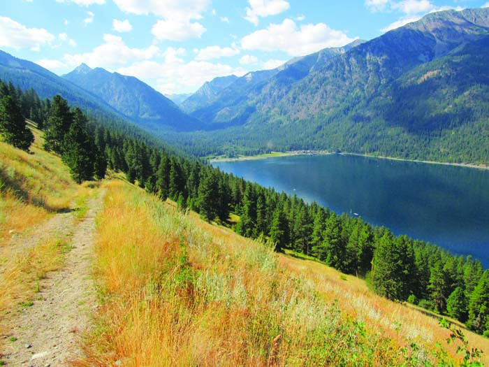
And of course there is Wallowa Lake.
The ridges that hem in the fjord-like lake are moraines — the piles of debris that a glacier scoured from the mountains and deposited on either side.
(Those are lateral moraines. The lower ridge at the northern end of the lake, the aptly named terminal moraine, marks the glacier’s farthest extension.)
I have had occasion recently to ponder our region’s much icier past while reading an intriguing new book, “The Age of Melt” by Lisa Baril.
The book’s subtitle explains its premise: “What glaciers, ice mummies, and ancient artifacts teach us about climate, culture, and a future without ice.”
Baril writes about how the Earth’s warming climate has melted not only glaciers but also “ice patches” — budding glaciers that never quite gained enough mass to start moving.
These receding ice patches have uncovered ancient artifacts such as bows and arrows, some several thousands years old.
Even more compelling, melting has disinterred a few human bodies.
The most famous, about whom Baril writes in detail, was named Ötzi, for the Ötzal Alps near the Italian-Austrian border where hikers found the body in 1991.
Carbon-dating tests showed Ötzi died about 5,300 years ago.
The shrinking of ice patches has also yielded dozens of items elsewhere in the Alps, in Norway and in Yukon, among other sites. Enough to keep archaeologists busy for decades.
The recession of glaciers is for me one of the more compelling parts of the wider topic of climate change.
Although there is legitimate debate about some aspects — most notably the validity of the computer models on which predictions of future effects are based — the matter of glaciers is beyond dispute due to the vast catalog of photographs showing how hundreds of alpine glaciers have shrunk, and in some cases disappeared, over the past century.
(Alpine glaciers are distinct from the polar ice sheets, which hold almost all of the fresh water on the planet.)
Several Cascade volcanoes still harbor glaciers, including the Three Sisters, Mount Jefferson and Mount Hood in Oregon. Those have receded considerably over the past several decades.
A 2024 report from the Oregon Glaciers Institute, a nonprofit formed in 2020, concluded, based on photographs, that Mount Hood’s 17 glaciers have lost 17% of their area since 2016, and 39% since 1981.
There isn’t a great deal of data about the relatively recent history of glaciers in Northeastern Oregon — the past few centuries.
The much more distant past, though, has been studied with some detail.
Emily Geraghty, then a geology student at Whitman College in Walla Walla, Washington, studied the glacial history of the Elkhorns in the late 1990s. She concluded, based on moraines and other evidence, that several glaciers were grinding away at the mountains during two major glacial periods, one between around 150,000 years and 200,000 years ago, the other between roughly 10,000 and 30,000 years ago.
No glaciers remain in the Elkhorns. Or the Greenhorns or Strawberrys.
Some years, particularly in the Wallowas, snowpatches survive the summer in alcoves on north-facing slopes where the sun rarely reaches.
But glaciers typically form only over a century or longer, as the layers of snow pile up and the weight compresses the snow into ice that can flow.
The last glacier in Northeastern Oregon was the Benson, in the Wallowas. The Benson Glacier was on the northeast slope of Glacier Mountain, along the same ridge that tops out on the summit of Eagle Cap.
A snowfield remains, but most of the resources I’ve consulted conclude that the Benson no longer qualifies as a glacier — that is, a mass of ice that shows evidence, such as crevasses, that it is moving. The glacier’s death, as it were, probably happened sometime in the past century, possibly in just the past several decades.
The Oregon Glaciers Institute, a nonprofit started in 2020, deems the Benson as a former glacier.
Ethan Shaw, a friend and occasional contributing columnist to the Herald, is a volunteer with the institute. He’s been studying “permanent” snowfields in Northeastern Oregon for the past several years.
He described these snowfields, in a piquant turn of phrase, as the “ghosts of alpine glaciers that carved the range tens of thousands of years ago.”
Shaw said the consensus among people who have studied the Wallowas, and the site of the Benson glacier in particular, is that although the glacier no longer exists, it likely was still a glacier well into the 20th century and potentially into the 21st century. A photo from the 2000s show what might have been crevasses — the slits that form in a glacier as it moves, and a sign that a glacier is active.
Lacking the ice patches that Baril wrote about, I doubt our mountains will yield the fascinating artifacts that scientists have marveled over in the Alps and elsewhere.
But the topic seems to me eternally fascinating.
More so because I can stand in my living room and look west at the triangular tip of Elkhorn Peak, the handiwork of ice so ancient that I might not believe its existence if it hadn’t left evidence so blatant and so beautiful.
Jayson Jacoby is the editor of the Baker City Herald. Contact him at 541-518-2088 or jayson.jacoby @bakercityherald.com.