Out and About: Savoring the solitude on Wheeler County’s Sutton Mountain
Published 10:55 am Tuesday, April 22, 2025
I was so fixated on the grand sprawl that is Wheeler County, so focused on its tens of thousands of acres of rimrock canyons and desolate dry washes, that I almost stepped on a square foot of pain.
I noticed the hedgehog cactus while my boot was just starting its descent.
I recoiled and lurched to the side, as though I had seen not a stationary succulent but a quite speedy rattlesnake.
I suspect the soles would have protected my ankles from the worst of the perforations.
But my experience with cactus spines is rife with frantic gesticulations and ample profanity, and like as not I would have come away with at least a few lacerations to lament on the hike back.
I can’t plead ignorance on the matter.
The greatest of Oregon guidebook authors, William Sullivan, mentioned hedgehog cactus in his superbly accurate description of the climb to Sutton Mountain.
And here they were, lurking among the basalt boulders, sagebrush and bunchgrass near the crest of this spine of high ground a few miles north of the Painted Hills unit of the John Day Fossil Beds National Monument.
I avoided impalement, or any other unpleasantness, during my visit.
It was my first — hardly uncommon in a part of Oregon that is remote, and little traveled, even by the standards of Eastern Oregon.
I was driving home from my daughter Olivia’s tennis tournament in Madras, and on a fine spring day — Easter Sunday, in fact — I was loath to retrace my usual route through Mitchell and John Day and Austin Junction.
Enticed by the revised edition of Sullivan’s “100 Hikes: Eastern Oregon,” a true trove of treasures, I turned off Highway 26 in the western suburbs of Mitchell and drove north on Highway 207.
This chunk of Oregon — the north-central part, to describe it broadly — has long fascinated me.
The region, for which Wheeler County, Oregon’s least populous with about 1,400 residents, is the center, is traversed by several state highways, but none is a thoroughfare.
Most of the traffic through Eastern Oregon stays on Interstate 84 to the north, or either U.S. Highway 26 or U.S. Highway 20 to the south.
Wheeler County has just three incorporated cities — Fossil, the county seat, Mitchell and Spray.
For the whole of the hike from Highway 7 to Sutton Mountain — about 3.8 miles one way — there is little indication that people live nearby.
The route, which mainly follows an old road bed, climbs a gulch and curves onto a grassy slope with an unimpeded view to the east, north and west.
I was impressed, and not a little surprised, both by how much country there is, and by how torturous the terrain.
I’ve driven all the highways in the region — the roads linking, among other places, Spray and Service Creek and Fossil and Heppner and Condon and Monument — but those paved byways give travelers only a token sense of the topography.
(Nor is this surprising — highway engineers as a rule prefer not to hack roads across cliffs, although I imagine some would relish the immense explosions that would be required.)
As I walked a relatively flat section of the trail and was able to concentrate on something other than gulping in lungfuls of air — the route climbs about 1,650 feet and is rather steep in places — I noticed several miles to the north a snout of rimrock that must be at least a thousand feet high.
I later checked a couple maps, but neither put a name on this feature, which juts off a plateau near the John Dan River.
This absence seemed to me passing strange. The feature was the sort that justifies a highway pullout with a “scenic vista” sign, yet in this setting, with a succession of canyons and promontories extending for many miles in each direction, not every towering eminence warrants a name.
(At least not according to the cartographers. I’m sure the locals could tell you what the thing is called.)
Sutton Mountain is part of a 29,000-acre swath of public land that the BLM has designated as a wilderness study area. That means it could potentially be a candidate for congressional designation as a federal wilderness.
The study area already has some attributes of a wilderness — motor vehicles are restricted. The old road is blocked near Highway 207 by a locked gate.
I was a trifle early for the peak of the wildflower show.
Sullivan in his book mentions lupine, paintbrush, blue flax and stonecrop, but none of those species was blooming on Easter Sunday. But there was quite a lot of color to brighten the dun expanses of last year’s crop of bunchgrass.
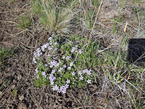
The pink-purple flowers of grass widows were ubiquitous, and I saw a few patches of phlox, the low-growing mats speckled with pink blooms.
I was more surprised to spot a couple shooting stars, a species I expect to see growing near water in alpine country.
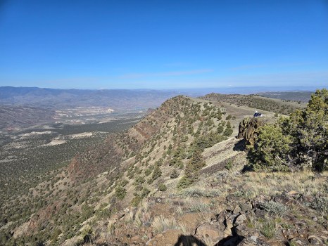
The old road climbs to a pass between two summits, the eastern one being the 4,694-foot peak of Sutton Mountain.
Both points are along a rimrock cliff that plunges 20 to 40 feet.
The view has the sort of vertiginous drama more typical of high mountains such as the Elkhorns and Wallowas. As I stood on the precipice I felt slightly queasy, as I always do when looking over the brink into empty space.
I picked out three Cascade volcanoes to the west and northwest — Mounts Jefferson, Hood and Adams.
The most stirring vista, though, is to the south.
The Painted Hills, where I had hiked a couple weeks earlier, were conspicuous several miles away — and 2,200 feet below.
Black Butte, the conical peak that looms above Highway 26 several miles west of Mitchell, seemed a bit puny from my elevated vantage point.
(Although its apex is actually higher, at 5,059 feet.)
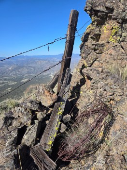
Just before my encounter with the cactus I noticed a barbed wire fence.
It ended, as such fences often do, where the rimrock becomes vertical, creating an obstacle that not even the nimblest cow could get around.
A length of rusted wire was wrapped around a boulder that served as an anchor. A coil of wire was stashed beside wooden support posts fashioned, I’m almost certain, of juniper, the only abundant source of wood for dozens of miles around.
As I often do when I come across such a structure in a remote place I wonder who built it, and when.
Was it a fair day like today, or a blazing August afternoon or frigid January, the north wind shoving the wind chill factor below zero?
Is the person still alive who wrapped the wire around the posts or has he long since gone to his grave, leaving as part of his legacy this simple assembly that still serves its purpose.
Almost certainly I’ll never have answers.
But it is of no matter.
This place, and these views, remain, rare bits of the past that persist, stubborn islands of stability amid the roiling and turbulent stream of time.
Jayson Jacoby is the editor of the Baker City Herald. Contact him at 541-518-2088 or jayson.jacoby @bakercityherald.com.


