Republicans in Oregon Legislature seek to repeal state’s controversial wildfire risk map
Published 5:53 am Wednesday, March 19, 2025
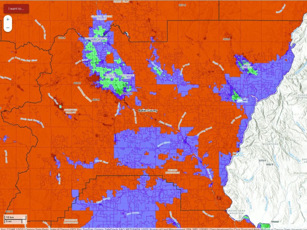
- This map, produced by the Oregon Department of Forestry and Oregon State University, shows three levels of wildfire risk. The map covers the entire state; this is a cropped version showing Baker County. Orange-red areas are deemed high risk, purple areas are moderate risk, and green areas low risk.
Republicans in the Oregon Legislature introduced a bill Tuesday, March 18, that would repeal the map showing the wildfire risk for every tax lot in the state, a map that critics, including Baker County commissioners, say is rife with mistakes that can reduce property values and force some rural residents, including in Baker County, to spend more money if they want to build a home on their land.
House Bill 3944 would repeal the map and regulations for landowners whose property is both rated as at extreme risk and is also in the wildland-urban interface, typically an area in or near a fire-prone forest.
“Oregonians deserve real solutions, not more government overreach,” Sen. Daniel Bonham, R-The Dalles, the Senate Republican Leader, said in a press release. “This new legislation is a unified effort by Republican legislators to repeal the deeply flawed wildfire hazard maps and restore fairness for over 100,000 homeowners. We have an opportunity to correct past mistakes and bring certainty back to property owners across the state.”
“It’s unfair to penalize property owners while our state and federal governments fail to manage our forests and public lands,” said Rep. Christine Drazan, R-Canby, House Republican Leader. “This bill empowers rural Oregonians by allowing them to make decisions on how to manage their properties.”
“Instead of threatening Oregonians with unfair mandates, this bill incentivizes local communities and homeowners to take responsible protective measures to protect their properties, creating a plan that will actually keep Oregonians safe,” said Rep. Bobby Levy, R-Echo.
Creating the map was part of a bill the Oregon Legislature approved in 2021, in the wake of the Labor Day 2020 blazes that destroyed hundreds of homes in western Oregon.
Baker County commissioners also have expressed concern about the potential effects of the map, which was released in early January.
Commissioners urged property owners to file an appeal with the state if their parcels are listed as having a high wildfire risk and are also within the wildland-urban interface (WUI). The appeal deadline was March 10.
In February, the three commissioners signed a letter opposing the latest version of the map that shows wildfire risks for every parcel, public and private, in the state, as well as boundaries of the WUI.
Commissioner Christina Witham said county officials have been fielding questions from property owners since the Oregon Department of Forestry released the map earlier this winter.
The chief concerns, Witham said, involve tax lots that are both high risk and within the WUI — those whose owners received a mailed notice from the state earlier this winter.
Witham said the fear is that owners of such property would be required, under state rules, to take steps to protect their homes against fire. In addition, properties in the WUI that are also rated as high risk would also have to comply with different state standards if they want to build a home on the land, which could increase the construction cost.
Witham said another concern is that properties in the high risk category could either lose homeowners insurance or pay higher premiums.
In 2023 the legislature passed a bill that prohibits insurance companies from using any state wildfire risk map to set premiums or determine whether to insure a property.
Witham and other critics of the map, including state Rep. Mark Owens, the Republican from Crane whose district includes Baker County, believe the map mistakenly places some properties within the high risk zone even though the owners have taken steps, such as maintaining green grass around their home and trimming trees and brush, to reduce the fire risk.
Kerry Savage, Baker County assessor, said he doesn’t have an estimate for the number of parcels that are within the WUI and rated at high risk.
Parcels that meet both criteria are concentrated in certain areas, including:
• The southern and western edges of Baker Valley, particularly in the Pine Creek/Ben Dier Road/Hunt Mountain Road areas.
• Sumpter.
• Other parts of Sumpter Valley, including Deer Creek Road.
• Greenhorn (also Granite, which is in Grant County).
• Areas north and east of Unity Reservoir.
• Along Highway 7 between Salisbury Junction and near Phillips Reservoir.
• Areas along Old Auburn and Griffin Gulch roads south of Baker City.
• Sparta area.
• East Eagle Creek.
• Fringes of Pine Valley, mainly on the north and northeast.


-
eEdition

-

-