Relishing the view
Published 3:31 am Tuesday, March 11, 2025
- Krag Peak in the Wallowa Mountains on March 1, 2025, seen from near Eagle Creek. Krag Peak in the Wallowa Mountains on March 1, 2025, seen from near Eagle Creek. (Lisa Britton/Baker City Herald)
A hike without a view is like a plate of tofu.
Nutritious but bland.
Unsatisfying.
Eminently forgettable.
By contrast, trudging the final few steps to a promontory, where the terrain suddenly yields to reveal a panoramic vista of forest and mountain, is akin to a perfectly seared steak or a slice of huckleberry pie topped with soft, slightly melted vanilla ice cream.
Rewarding.
Memorable.
Northeastern Oregon, with its tortuous topography, boasts a wealth of worthy vantage points.
And although the presence of snow can embellish almost any scene, it also poses a formidable obstacle to the traveler.
Many stirring sights are all but inaccessible during winter except to those with experience traversing backcountry where a variety of dangers lurk, including avalanche and hypothermia.
But remote summits such as the great peaks of the Elkhorn, Wallowa and Strawberry ranges, and the lower but still impressive mountains elsewhere in the Blues, aren’t the only enticing destinations.
During the past month or so I plodded in snowshoes to three places rich in viewpoints.
I drove a well-maintained state highway in two cases. My route in the third is a gravel U.S. Forest Service road that’s plowed regularly to allow access to log trucks but is better suited to four-wheel-drive vehicles due to patches of slush, ice and mud.
This trio is just a smattering of the options in the region.
Every state highway, and quite a few county roads, can take you places where even a short hike on snowshoes, or a glide on cross-country skis, affords the sorts of expansive views that publishers of coffee-table books and calendars covet.
Forshey Meadow — Wallowas
This trip is scenic even if you never get out of your car.
The route, along Highway 86 east of Baker City, passes my favorite roadside vista in Northeastern Oregon.
The highway, after 3 straight miles through the sagebrush sea, veers left and climbs to a crest at milepost 10 (the distance measured from Interstate 84 in Baker City).
Suddenly the windshield is filled with the Wallowas.
My wife, Lisa, and I picked March 1 for the trip because it was a cloudless day. The white mountains seemed almost to be etched from the blue background, rather like the mountains that scroll endlessly in the backdrop of Wile E. Coyote and Roadrunner cartoons.
The Wallowas are so broad that no single point (save from an aircraft or, I suppose, the perspective of a skydiver) reveals the whole of the range and its complement of more than three dozen summits topping 9,000 feet.
But the view from Highway 86 at its intersection with Keating Cutoff Road is generous in its scope, ranging from the distinctive trio of China Cap, Burger Butte and Mule Peak at the left to Cornucopia Peak at the far right.
The Wallowas continue to crowd the northern skyline as the highway descends to Keating Valley for a few miles and then swings into the sinuous lower Powder River Canyon.
We turned onto Sparta Lane just past milepost 23 and climbed into the foothills. Sagebrush gives way to ponderosa pines and then, after Forshey Meadow — a blindingly white expanse on a sunny winter day — to the typical mixed conifer forest where pines mingle with firs and tamaracks.
A Forest Service logging operation is ongoing in the area, so Forest Road 70 is plowed up to Five Corners, where, as the name suggests, a quintet of gravel roads come together.
(About a mile before Five Corners, the road passes a home — heed the signs urging drivers to slow to 15 mph in deference to kids and dogs.)
There’s ample parking space where the plows have pushed berms almost as high as a basketball hoop.
Snowshoers and cross-country skiers have multiple options, each of which comes with a view.
The roads to Empire Gulch and to Lily White Guard Station are both groomed for snowmobiles. There are other ungroomed roads, and the forest is not dense, so cross-country travel is easy.
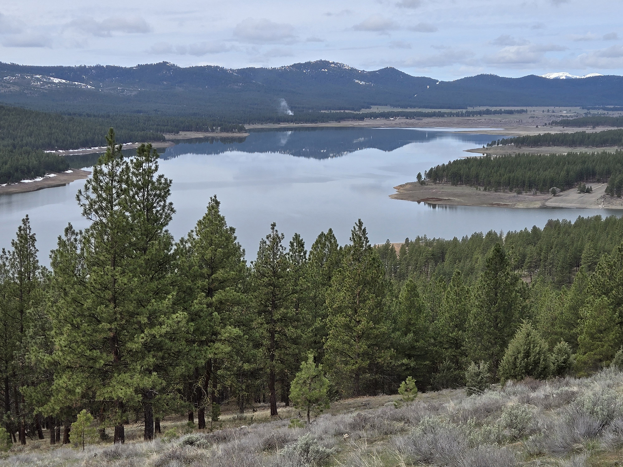
Our goal was the dramatic look across Eagle Creek Canyon to the peak that dominates this corner of the Wallowas — Krag Peak.
Although its summit is of middling height by Wallowa standards, at 9,048 feet, Krag’s west face is steep and imposing, with rocky ribs and gullies. An experienced mountaineer could hardly avoid pondering potential ascent routes when confronted with the view.
Although the topographic nature of the Wallowas — the range is mainly a network of long ridges studded with summits that aren’t much taller than the ridge itself — can sometimes make it difficult to pinpoint a particular peak.
But Krag is easy to pick out due to the two pinnacles, separated by a spine extending hundreds of yards, that make up its apex.
Although considerably shorter than its nearest neighbor to the east — Red Mountain, at 9,555 feet the tallest point in Baker County — Krag Peak, as seen from near Five Corners, seems to my eyes as grand as any eminence in the Wallowas.
Larch Summit — Elkhorns, Greenhorns
This pass on Highway 7 about 28 miles southwest of Baker City, also known as Huckleberry for the mountain a couple miles to the east, is nothing like as dramatic as, say, McKenzie Pass in the Cascades.
But from a hydrologic standpoint, Larch Summit is significant.
The low spot lies along the spine of high ground that extends more than 20 miles and divides the Powder River watershed to the north from the Burnt River to the south.
More important for winter recreation, the Oregon Department of Transportation snowplow drivers who maintain Highway 7 push the snow far enough to create parking space for several vehicles on the west side of the pass.
Several Forest Service roads, none of which is plowed during winter, coalesce at Larch Summit.
One heads east toward Huckleberry Mountain and leads to unobstructed views of the west side of the Elkhorn Mountains across Sumpter Valley.
My favorite routes, though, are west of the pass.
The two main routes, which snowmobilers sometimes use, are Forest Roads 1080 and 1075. Road 1080, which starts just north of the pass, meanders along the north side of the Burnt-Powder divide. There are occasional views of the Elkhorns through the forest.
Road 1075 begins right at the pass, and it more or less mimics 1080, but on the south side of the divide. The forest here is less dense and dominated by ponderosa pines, as is typical for south-facing slopes in the Blue Mountains due to the much greater sun exposure that favors the sun-loving and drought-tolerant ponderosas over Douglas-firs, grand firs and tamaracks, which prefer the shadier, damper northern exposures.
A third option is the Blue Mountain Off-Highway Vehicle Trail. It meets the highway at the same place as Road 1075, but instead of veering left, the OHV trail heads straight west and sharply uphill. The grade moderates, though, and about a quarter-mile from the highway, where the road crosses a fence line (the cattle guard was buried in snow when I snowshoed the road on March 2), a rock outcrop just to the south makes a fine viewpoint.
The vista extends south to the mountains above Unity, including the distinctive flat top of aptly named Table Rock. Strawberry Mountain, the tallest peak between the Elkhorns and Steens Mountain, hogs the horizon. Other prominent points are Dixie Butte to the southwest, and the Greenhorns, topped by Vinegar Hill, almost due west.
Skyline Road — Elkhorns and more
The other highway that crosses the Burnt-Powder divide is Oregon 245, the Dooley Mountain Highway.
At Dooley Summit, as at Larch, ODOT snowplows carve out a parking area on the west side of the pass, near a shed that protects a mountain of gravel that plows spread on the often icy highway.
Forest Road 11, the Skyline Road, runs west from the highway. Its western terminus, more than 20 miles away, is at Highway 7 a mile and a half south of Larch Summit.
Lisa and I snowshoe the Skyline Road as much for its wind-sculpted snowdrifts as for its views.
It’s an ideal tableau for drifts.
This is steep country, and the road in places was gouged from the slope, leaving a nearly vertical cutbank.
Moreover, the road, as its name suggests, stays near the spine of the divide, where it’s exposed to winds that often gust to gale force on this elevated ground.
(A temporary weather station was erected after the 2015 Cornet-Windy Ridge Fire on Bald Mountain, a few miles west of Dooley Summit and the tallest point on the Powder-Burnt divide. The station, which was intended to record heavy rain that could potentially lead to flash floods after the fire denuded the steep slopes, often recorded wind gusts topping 50 mph. Alas, the station was removed several years ago.)
The deepest drifts — more than 10 feet high — typically are on a section of the Skyline Road that’s just north of the top of the divide. We had neither the time nor the energy to make the 1,000-foot climb on the day of our trip, Feb. 9.
But even within a few hundred feet of the highway, the wind had piled snow into head-high drifts next to spots nearly scoured to the ground.
As for views, we snowshoed a mile or so to a road intersection where the open east face of Bald Mountain is framed by terrain — a perfect tableau for a painting.
The 2015 fire killed most of the trees here, so nothing impedes the vista. The Wallowas and Elkhorns take up most of the northern horizon. To the south, Cottonwood Mountain is prominent.
Photo info
Mug of Jayson to run with column sig
Bald Mountain:
Lisa Britton/Baker City Herald
Bald Mountain seen from the Skyline Road south of Baker City on Feb. 9, 2025.
Cornucopia Peak:
Lisa Britton/Baker City Herald
Cornucopia Peak, far right, and Red Mountain, far left, on March 1, 2025, seen from near Eagle Creek.
Decaying ponderosa:
Jayson Jacoby/Baker City Herald
The decaying stump of a ponderosa pine tree on March 2, 2025, near Larch Summit.
Greenhorn Mountains:
Jayson Jacoby/Baker City Herald
The Greenhorn Mountains on March 2, 2025, seen from near Larch Summit.
Krag Peak from Red Knob:
Lisa Britton/Baker City Herald, File
Krag Peak in March 2020 seen from near Eagle Creek.
Krag Peak:
Lisa Britton/Baker City Herald
Krag Peak in the Wallowa Mountains on March 1, 2025, seen from near Eagle Creek.
Power Line View:
Jayson Jacoby/Baker City Herald
A power line running southwest near Whitney Valley, in western Baker County, on March 2, 2025.
Red Mountain:
Lisa Britton/Baker City Herald
Red Mountain, just right of center, the highest point in Baker County at 9,555 feet, on March 1, 2025, seen from near Eagle Creek. The mountain at left is Krag Peak.
Skyline Road snowshoeing:
Lisa Britton/Baker City Herald
Snowshoeing Feb. 9, 2025, on the Skyline Road near Dooley Mountain, in Baker County.