Several new fires reported north of Durkee after lightning storm
Published 3:51 pm Monday, July 22, 2024
- Screenshot 2024-07-22 at 3.53.36 PM.png
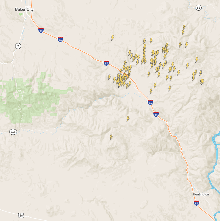
At least seven new fires, all started by lightning on Monday afternoon, July 22, were reported north of Interstate 84 in eastern Baker County, according to the BLM Vale District dispatch center, and one fire has grown to an estimated 4,000 acres and prompted a Level 3 evacuation notice — leave now — for residents on Plano, Vandecar and Manning Creek roads.
The fire nearest the freeway, the Crandall Fire between Plano and Manning Creek roads, is estimated at 10 acres, and was 80% contained as of 8 p.m. Monday, said Larisa Bogardus, public information officer for the BLM’s Vale District.
ODOT closed the freeway between Baker City and Ontario due to the fires.
Two other fires are on the north, Powder River, side of Little Lookout Mountain. The Daly Fire, near the head of Daly Creek about 10 miles south of Richland, is 8.9 acres. A bulldozer dug a double line around the fire, and crews are mopping up the blaze, Bogardus said. The Chalk Fire near Richland, also on private land about 5 miles south of Richland, was contained at 1.1 acres by a Forest Service engine.
Two fires burning close together, Thompson and North Thompson, are burning near the confluence of Trail and Durkee creeks about 3 miles north of Durkee. Bogardus said the fires, along with a third nearby unnamed fire, combined total about 10,000 acres, and fire crews are working to protect multiple structures threatened. Those fires prompted the Level 3 evacuation notice.
Five separate fires in the Timber Canyon area southwest of Richland are combined estimated at 167 acres, Bogardus said.
Late Monday another new fire, Coyote, was reported east of the Snake River Road southeast of Richland. It was estimated Tuesday morning at 1,200 acres and had burned close to Brownlee Reservoir.
The storm also passed over parts of the Durkee Fire, Oregon’s largest at 224,000 acres, but little to no rain was reported, said Jessica Reed, public information officer for the management team overseeing firefighting efforts.
The wind has shifted from west and northwest to south and southeast, Reed said.
That could pose a challenge for firefighters trying to prevent flames from spreading north and west through the Burnt River Canyon north of the river.
Reed said crews working on the Durkee Fire could be available to head to any new fires reported.
On the Durkee Fire, she said firefighters are trying to contain the fire’s spread on the west side, including around Deer Creek north of the Burnt River as well as from Malheur Reservoir Road to Clarks Creek south of the river.


-
eEdition

-

-