Crews make progress on Cow Valley Fire; Falls Fire closes section of Highway 395
Published 5:40 am Tuesday, July 16, 2024
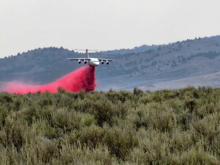
- An air tanker drops retardant ahead of the Cow Valley Fire in northern Malheur County.
Crews have slowed growth on Oregon’s biggest wildfire, the Cow Valley Fire in northern Malheur County, and evacuation notices have ended for residents along Highway 26 northwest of Vale.
Trending
The human-caused fire, which started July 11 and is under investigation, has burned about 133,400 acres and was 16% contained as of Tuesday morning, July 16. There was “minimal” growth in the fire on Monday, according to an update from the management team overseeing firefighting efforts.
With the fire no longer spreading to the west, the Malheur County Sheriff’s Office removed the evacuation preparation notice for the Highway 26 corridor. The city of Vale is not threatened, according to the sheriff’s office.
An area around Westfall, west of Vale, remains under a Level 2 notice, meaning residents should be prepared to leave. The fire has advanced slowly on its west side, north of Westfall.
Trending
The Red Cross evacuation shelter in Ontario will demobilize at noon on July 16. However, if citizens are evacuated from the Westfall area, plans have been made and a shelter will be set up in Vale. More information is available by calling 541-709-7726.
With the declining threat to homes and other structures, fire managers have released the Oregon State Fire Marshal task forces that had been working on the fire.
“Crews on all shifts had success strengthening primary firelines (on Monday),” according to a Tuesday morning update from the fire management team. “Aviation worked to support ground resources with water and fire-retardant drops as weather allowed. Firefighters walked the entire northern edge checking for heat. The Unstaffed Aerial System (UAS) was equipped with an infrared (IR) camera to detect lingering heat signatures on the line, none were found.”
Another human-caused fire in the area, the Bonita Road Fire, which also was reported on the morning of July 11, has not grown in the past few days and is 80% contained at 2,727 acres.
Falls Fire grows rapidly, closes Highway 395
The situation is quite different with another human-caused fire, the Falls Fire about 20 miles northwest of Burns in the Malheur National Forest.
That fire grew substantially on Monday. Its size was estimated at 64,000 acres, but fire officials planned to update that on Tuesday. About 650 people are assigned to the fire.
The fire, which started moving southeast due to winds from a thunderstorm on Monday, burned to within about 2 miles of Highway 395, the main route between John Day and Burns. The highway was closed between Seneca and 7 miles north of the Highway 20 junction just east of Burns.
The Izee-Paulina Highway was also closed, and all Forest Service roads in the Emigrant Creek Ranger District are closed.
Evacuation notices for the Falls Fire include:
Level 3 (leave immediately)
Grant County
• All areas east of Crooked Creek and south of Camp Creek, west of Highway 395.
• The area west of Highway 395 and south of Forest Service Road 17, extending east to the Grant and Harney County line, including Rock Springs Campground.
Harney County
• Southern Silvies Valley and Forest Service Road 28.
• The area east of Highway 395 and west of Rattlesnake Road, extending four miles south of the Forest Service boundary on Rattlesnake Road, and north of Poison Creek on Highway 395.
Level 2 (Be Set)
Grant County
• All areas previously at Level 1 south of Scotty Creek Road and west of Highway 395, now including the town of Seneca.
• The area of Silvies Valley west of Highway 395 to the Grant/Harney County line.
Harney County
• The area south of Poison Creek, east of Highway 395, and north of Highway 20, extending east to Buchanan (excluding the area of Fort Harney, which remains Level 1).
• Areas north of Buchanan to the Harney and Grant County line, including Pine Creek Road and the Van area.
The American Red Cross is operating a shelter for evacuees from the Falls Fire. The shelter is at Grant Union High School. There is limited space for large animals and dry camping at the Grant County Fairgrounds in John Day.
Marketplace


-
eEdition

-

-
