Over the Blues: Alpine splendor in the Eagle Cap Wilderness
Published 10:45 am Monday, July 15, 2024
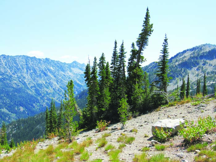
- Shaped by persistent wind and snow, subalpine fir and whitebark pine trees in the Eagle Cap Wilderness near Maxwell Lake show grit as they gain tenuous footholds.
I met “Maxine” on the third of six switchbacks leading to Maxwell Lake high in Eagle Cap Wilderness, Oregon’s largest.
Retired a decade ago, Maxine said she chooses one day each summer to hike the 4-mile uphill trail to the lake. She has chosen this day because it is relatively cool with less wildfire smoke.
“I’ve been doing this every year for 50 years,” said the Wallowa County resident. “It’s proof I’m still alive — and can do something extraordinary.”
Reach the trailhead by driving the Lostine River Road south 17 miles. Best hiked June through September, the trail switchbacks the first three miles. The last mile goes “straight up” and can be challenging in June and July while snow lingers.
Hiking the trail, I encounter only a few hikers, dust, squirrels, ravens and gray jays. Around every corner is a jaw-dropping view.
Early in the hike, at 0.2 miles, the trail crosses Maxwell Creek. When snowmelt reaches its peak, in June and early July, the crossing can be dicey. I cross on well-placed logs. Later in the summer, hikers can boulder hop. Hiking poles help with balance.
The trail climbs past granite outcroppings sparkling in sunlight, then enters shaded forest. Soon I meet a party that includes a chihuahua wearing booties to protect its paws. I bend down to say hello. The chihuahua looks at me, thinks Sasquatch, tucks tail and flees.
Continuing up the 2,450 feet in elevation gain, I begin feeling sorry for myself. I’m lugging a pack with three water bottles, medical supplies, snacks, a space blanket — essentially everything but the kitchen sink.
Then I meet someone even more loaded down. A woman carries a baby strapped on front and a pack on back. The baby is crying. Then laughing. Mom bravely soldiers on.
Finally I reach the end of the switchbacks and start the last mile — the “straight up” challenge. A hiking pole helps with balance as I clamber up to a pass at 7,790 feet elevation.
When at last I descend to the lake, at 7,749 feet, backdropped by alpine splendor, I am enthralled at its clearness. Even in midday, small brook trout occasionally jump. Diamonds sparkle on the tranquil water.
Several campsites are set back from the north shore. Be aware, though: The area can be buggy, especially evenings, so if camping overnight bring insect repellent and grit.
I sit on a granite boulder and enjoy lunch, then snap pictures before heading down the mountain. The trail is steep and slippery, earning a moderate difficulty rating in the book “Hiking Oregon’s Eagle Cap Wilderness.” I slip-slide down, halting occasionally to admire the panoramic views and to give my aching toes a rest.
Finally, after requiring about 3.5 hours to climb to the lake and 3 to slide back down, I limp across the bridge over the Lostine River and back to the car. I’m an older hiker who prefers not to rush. Your hike will probably take less time.
The drive back to pavement and Lostine also earns a “moderate difficulty” rating. Washboard and bumps require a rig with high clearance, or a driver skilled at dodging the worst obstacles.
Along the way I see signs for several trailheads — Frances Lake and others — which sparks thoughts of future adventures in “the Alps of Oregon.” First, though, I’ll let my toes recover.
As always, leave only footprints and take only pictures. Whether in town or on the trail, try to leave your surroundings better than you found them.