Exploring a remote ‘road’ amid fall colors
Published 2:01 pm Monday, October 18, 2021
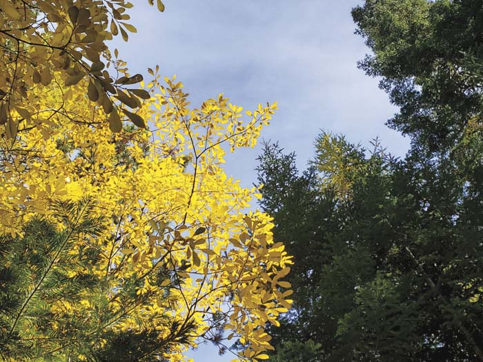
- Colorful autumn foliage along the North Fork of Anthony Creek on Oct. 9, 2021.
I like to hike on roads that are slowly ceasing to be roads.
Trending
The transition from maintained road to decrepit track typically is a process measured in decades.
But the actual rate depends on natural forces, particularly those which belong under the category of erosion.
A summer cloudburst, for instance, can render a road all but impassable, or at least sections of it, in just a few messy minutes.
Trending
If the road runs through forest, a powerful gale can topple enough trees to cut off easy access, at least until somebody comes along with a chain saw.
Generally, though, a road left alone, untouched by bulldozer or grader, will only gradually degrade, its decline defined by the accumulation of many small wounds.
A boulder dislodges a culvert, allowing a stream to divert onto the road and begin gouging ruts where tires pass (or passed).
Scree from a tall cut sloughs onto the grade, slowly narrowing the tread.
The first encroachment, though, on a previously pristine road, tends to be from trees.
Left to their own devices, trees will relatively quickly take over, either by way of seedlings sprouting where vehicles once went, or by growing tall enough that their tops begin to form a sort of tunnel of foliage.
Deciduous trees such as alders are especially adept at the latter, as their trunks tend to extend at an angle, rather than the typically straight boles of the conifers.
A line of alders can intrude on a road in just a few years in the absence of pruning.
You can often still drive a rig on such a road — but only if you’re not particularly concerned about the sanctity of its paint job.
I find it intriguing to hike such roads, to wonder when they began to decay, to see a culvert that no longer bears water and ponder what force caused it to cease its one simple function.
This sort of road beckons me to keep going, not so much for the potential view around the next bend or atop a knoll, but to see whether its progression is consistent — that the condition worsens the farther you go — or whether there are sections that seem almost untouched by nature.
I came across such a road recently in the mountains north of Anthony Lakes Highway.
I have an affinity for this area, where the granitic rocks of the northern Elkhorns give way to, and mingle with, the basalts that dominate the northern Blue Mountains.
There are no great peaks here, but it feels to me as wild and remote as ranges with loftier summits.
The dense forests are largely responsible, a mixture of doghair lodgepole thickets in places where the 20,000-acre Anthony Fire burned hottest in 1960, and old growth, with massive tamaracks, ponderosa pines, Douglas-firs and Engelmann spruces in some valleys.
One of those valleys is where the North Fork of Anthony Creek flows.
If you have a look at a map of the area you might well question my choice of “wild” and “remote” as adjectives.
There is certainly no shortage of roads.
Two roads to the north of the stream roughly parallel it for much of its length, and another road traces the valley south of the creek.
But none of these roads is heavily traveled.
And the one that I hiked earlier this month — the lower of the two northside routes, the one that stays close to the stream — looked to me as though it rarely has vehicle traffic other than an occasional ATV.
The exception is the first half mile or so from the road’s start at the North Fork Anthony Creek bridge on Forest Road 7312. That road, by contrast, is something of a thoroughfare, a well-maintained gravel road that connects the Porcupine Road to the north, with the Anthony Lakes Highway.
The North Fork road — Forest Road 7312-150 — is in decent shape in that first section, and the reason seemed to me obvious, as it ends at a fine campsite beside the stream.
Immediately past the camp, though, the firs and the alders intrude, turning the road into a gantlet.
I’m not an engineer but it seemed to me, based on the road’s condition, that it hasn’t seen a bulldozer’s blade for at least a few decades.
The roadbed is generally intact, but the drainage system much less so.
In several places a roadside spring or stream, rather than trickling harmlessly under the road through a culvert, flows freely onto the surface, making for a slightly mucky hike, albeit for short distances.
In its heyday, though, this road must have been a pretty easy drive. It’s relatively wide, as mountain roads go, and based on the height of some of the cuts, a considerable amount of excavation, and probably some expenditure of explosives, were required.
Because the road is at the bottom of the valley — the flattest part, obviously — the grade is moderate.
I was hiking with my wife, Lisa, and our son, Max, and we turned back where two tributaries come together, about two and a half miles from the 7312 road. Another road branches off to the south at this confluence. The road once crossed the creek, but the two big culverts that made this possible were yanked out. They sit side by side near the stream.
It’s not a difficult hike. The elevation gain from the 7312 road to where we turned back is about 900 feet. My map shows the road on the north side of the creek continuing up the valley for another half mile or so. The road on the south side of the creek connects to a network of roads in the High Mountain area.
I suspect many of these routes were built to aid firefighters working on the Anthony fire 61 years ago. The dense lodgepole thickets that thrive after blazes can all but obliterate hastily created fire roads, to be sure. But in an area that lacks official trails, this collection of “roads” entices explorers who don’t mind brushing aside an occasional alder branch or fir bough.
Marketplace


-
eEdition

-

-
