Work continues on fire in Elkhorns
Published 1:24 pm Tuesday, August 31, 2021
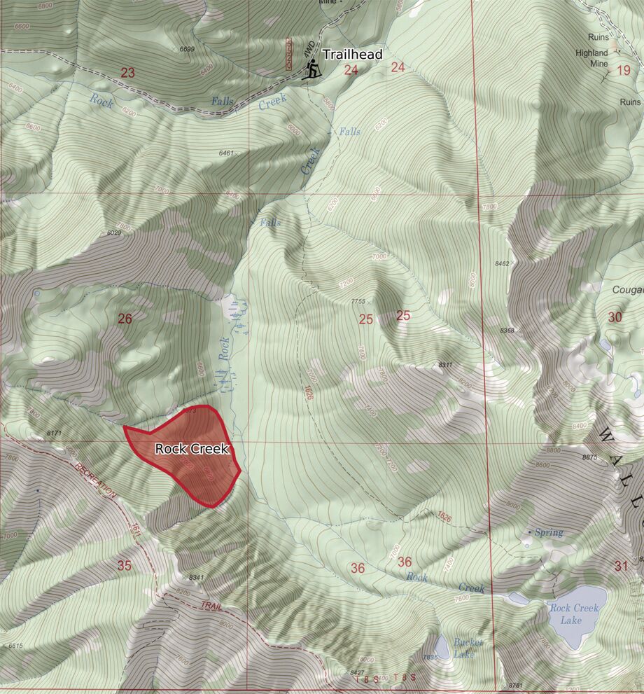
- Rock Creek fire map
An aerial armada that dumped thousands of gallons of fire retardant and water within several hours slowed a fast-moving wildfire that flared up Monday afternoon, Aug. 30 and has burned about 60 acres in one of the more inaccessible parts of the Elkhorn Mountains.
The blaze in the upper reaches of the Rock Creek canyon, about 13 air miles northwest of Baker City, started in a forest type where flames can race through in certain conditions, said Joel McCraw, fire management officer for the Wallowa-Whitman National Forest’s Whitman Ranger District.
But as of early Wednesday afternoon, Sept. 1, the fire was showing minimal growth, and ground crews had arrived to dig a fire break and set up hoses connected to pumps in Rock Creek, said Peter Fargo, public affairs officer for the Wallowa-Whitman.
More than 50 people were working on the fire, with a goal of building a line around the entire blaze within 48 hours.
“We’re still not out of the woods yet, but we feel pretty good about it for sure,” McCraw said on Tuesday afternoon.
Fire officials were considerably more concerned a day earlier, and in part because of the type of forest where the fire started.
Most of the trees in that part of the Rock Creek canyon are subalpine firs, a species that has high concentrations of flammable oil in the needles, and branches that tend to start near the ground, making it easier for fire to spread from the ground to the trees’ crowns.
“When it does get established in subalpine firs it can be a challenge to fight,” McCraw said. “Very volatile.”
Indeed, the fire, reported about 3 p.m. Monday by the lookout on Mount Ireland and by citizens, was torching trees and spreading through tree crowns, conditions too dangerous to have firefighters rappel from helicopters, McCraw said.
There are no roads within a mile of the fire, and the only access is by foot on the Rock Creek trail, which starts along a rough, four-wheel drive road, he said.
Given the limited access, all firefighting Monday evening and into Tuesday afternoon was from the air, McCraw said.
Two helicopters dropped water on flames, while five tankers — three multi-engine planes from Moses Lake, Washington, and a pair of single-engine planes from La Grande — spread retardant.
The air crews took advantage of natural fire barriers, McCraw said, including rock cliffs and fields of boulders and scree.
“In some areas the fire ran up into the cliffs and ran out of fuel,” he said.
The Rock Creek canyon, which runs roughly north-south, is bordered on the west by cliffs, with the Elkhorn Crest trail running just on the west side of the ridgetop.
There are thickets of subalpine fir elsewhere, interspersed with meadows along the creek. Rock Creek starts at Rock Creek Lake, one of the most scenic spots in the range, at the northern base of Rock Creek Butte, highest peak in the Elkhorns at 9,106 feet.
The fire started about 1 1/4 to 1 1/2 miles northwest of the lake, McCraw said.
The situation would have been even more dangerous had the fire started farther down the canyon, he said, because the forest is more contiguous, with fewer of the rock barriers that prevail at the head of the canyon.
The La Grande Interagency Hot Shot crew of 20 firefighters hiked into the fire on Tuesday afternoon, McCraw said.
The initial plan was to have smokejumpers work on the fire, but conditions were too dangerous, in part due to the terrain, to have them parachute into the fire Tuesday afternoon.
The Hot Shot crew was joined by two other crews, one from the Wallowa-Whitman and one from the Umatilla National Forest, as well as other firefighters.
The Rock Creek fire posed one of the bigger threats this summer on the southern half of the Wallowa-Whitman, which had a tranquil fire season compared with other parts of Oregon and the West.
Prior to the Rock Creek fire, there had 16 fires on the Burnt-Powder Fire Zone, which includes most of the southern half of the Wallowa-Whitman. Lighting sparked 13 of the fires, and three were human-caused (four now, with the Rock Creek fire).
The 16 fires burned a total of 8.2 acres.
McCraw said fire investigators have not had a chance to look at the site. The blaze was initially listed as human-caused, but is now shown on the Blue Mountain Interagency Dispatch Center’s website as “unknown cause — under investigation.”
He reminded forest visitors that the fire danger remains high, and that campfires are allowed only in designated campgrounds and recreation sites. There are no such sites in the upper Rock Creek canyon.
Forest Service officials urge the public to avoid the upper Rock Creek canyon while firefighting is ongoing.


-
eEdition

-

-